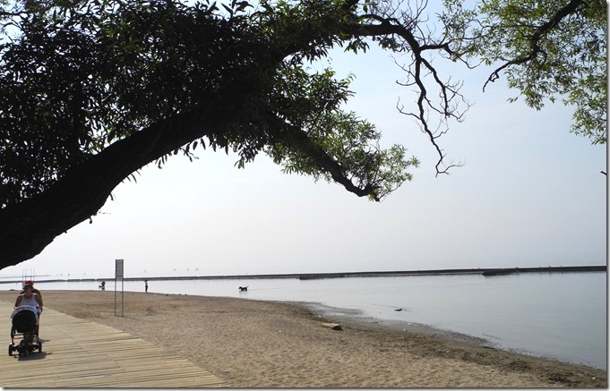
Sunnyside Beach and boardwalk in July of 2012
In 1834, when the City of Toronto was incorporated, it changed its name from York to Toronto. In that year, the area that became known as Sunnyside was far to the west of the city, as Toronto’s boundary extended only as far west as Peter Street. In 1848, John G. Howard purchased land in the remote area that today we call Sunnyside, and built a modest structure. He named it Sunnyside,” as it was on the “sunny side” of a grassy hill, a short distance north of the present-day Queensway Drive. Howard’s path to the lake was unobstructed until 1855, when the Grand Trunk Railway line, which extended from Toronto to Hamilton, was constructed along the lake front. On the site of Howard’s Sunnyside Villa, in 1876, the Sisters of St. Joseph’s Sacred Heart built an orphanage and named it the Sacred Heart Orphanage. Howard’s Sunnyside Villa was retained by the orphanage as an office. The villa survived until 1945, when the villa and orphanage were demolished to construct St. Joseph’s Hospital.
By the beginning of the 20th century, Sunnyside was one of Toronto’s most popular summer destinations, as residents sought relief from the hot humid weather that often descended during July and August. However, the city was expanding westward, and the area previously visited for its beaches, was becoming increasingly residential. This necessitated that a streetcar line be built, making Sunnyside more accessible, increasing its popularity.
A group of boys climbing on an old tree trunk at Sunnyside Beach in 1907. In the background is the restaurant of P. V. Meyer and Company.
This photo looks west at Sunnyside Beach in 1908. A train is headed eastward toward the old Union Station on Front Street, built in 1884. The lake is closer to the railway tracks than it is today, as landfill eventually extended the shoreline further south. The narrow early-day boardwalk is visible, and out in the lake can be seen a portion of the break wall. The entire break wall had not been completed when this photo was taken. The Lakeshore Boulevard of the future also has not yet been built. In this picture it is merely a dusty road. The streetcar tracks to the right of the roadway, originally went as far as Mimico, but in 1905 were extended as far west as Long Branch.
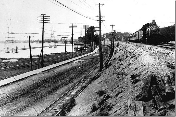
This photo shows Sunnyside Beach on 26 July 1911. It reveals how close the railway tracks were to the lake, in the days prior to landfill extending the shoreline further south. A row of “changing stations” can be seen beside the water, to allow bathers to change into their bathing attire. The building with the ornate turret, on the hill behind the train, is at the corner of Roncesvalles Avenue and Queen Street. The houses on King Street are also visible, on the hill, behind the train. It appears that there is a squatter’s shed on the beach, to the left of the “change stations.” The train cars belong to the Grand Trunk Railway.
Men working on the Sunnyside break wall in September of 1909. Eventually, 17,895 feet of break wall were constructed, creating the equivalent of over a hundred acres of protected waterways that were safe for bathers, between the shoreline and the break wall .
Bathing in the refreshing waters of Sunnyside in 1911, near the south end of Roncesvalles Avenue. In the background is the Sacred Heart Orphanage, built in 1876 on the site of Howard’s Sunnyside Villa.
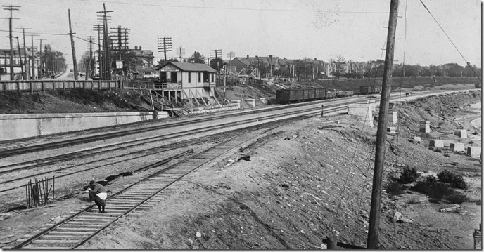
The railway tracks at Sunnyside, looking east toward downtown Toronto, and the old Sunnyside train station perched on the embankment. The photo is labelled in the Archives as being taken in 1912, but I had suspected that it was taken a few years earlier because of the station that appears in the photo. However, a reader has confirmed that the image was indeed taken in 1912. The houses along King Street are visible, and in the upper left-hand corner of the photo, Roncesvalles Avenue can be seen, extending northward. The lake can be seen to the right of the railway tracks, as the landfill that extended the shoreline further south has not yet started.
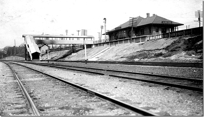
The new Sunnyside train station, in April of 1913. It overlooks the beach to the south.
Although Sunnyside was popular since the early-days of Toronto, the magnificent Sunnyside Amusement Park, which became known as “The Poor Man’s Riviera,” did not materialize until 1922.
Note: the historic photos in the this post are from the City of Toronto Archives.
To view the Home Page for this blog: https://tayloronhistory.com/
For more information about the topics explored on this blog:
https://tayloronhistory.com/2016/03/02/tayloronhistory-comcheck-it-out/
Books by the Author
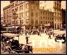
“ Lost Toronto”—employing detailed archival photographs, this recaptures the city’s lost theatres, sporting venues, bars, restaurants and shops. The richly illustrated book brings some of Toronto’s most remarkable buildings and much-loved venues back to life. From the loss of John Strachan’s Bishop’s Palace in 1890 to the scrapping of the S. S. Cayuga in 1960 and the closure of the HMV Superstore in 2017, these pages cover more than 150 years of the city’s built heritage to reveal a Toronto that once was.
“Toronto’s Theatres and the Golden Age of the Silver Screen,” explores 50 of Toronto’s old theatres and contains over 80 archival photographs of the facades, marquees and interiors of the theatres. It relates anecdotes and stories by the author and others who personally experienced these grand old movie houses. To place an order for this book, published by History Press:
Book also available in most book stores such as Chapter/Indigo, the Bell Lightbox and AGO Book Shop. (ISBN 978.1.62619.450.2) and may also be purchased on Amazon.com.
“Toronto’s Movie Theatres of Yesteryear—Brought Back to Thrill You Again” explores 81 theatres. It contains over 125 archival photographs, with interesting anecdotes about these grand old theatres and their fascinating histories. Note: an article on this book was published in Toronto Life Magazine, October 2016 issue.
For a link to the article published by Toronto Life Magazine: torontolife.com/…/photos-old-cinemas-doug–taylor–toronto-local-movie-theatres-of-y…
The book is available at local book stores throughout Toronto or for a link to order this book: https://www.dundurn.com/books/Torontos-Local-Movie-Theatres-Yesteryear
“Toronto Then and Now,” published by Pavilion Press (London, England) explores 75 of the city’s heritage sites. It contains archival and modern photos that allow readers to compare scenes and discover how they have changed over the decades. Note: a review of this book was published in Spacing Magazine, October 2016. For a link to this review:
spacing.ca/toronto/2016/09/02/reading-list-toronto-then-and-now/
For further information on ordering this book, follow the link to Amazon.com here or contact the publisher directly by the link below:
http://www.ipgbook.com/toronto–then-and-now—products-9781910904077.php?page_id=21
![f1244_it0154a[1] 1907 f1244_it0154a[1] 1907](https://tayloronhistory.com/wp-content/uploads/2013/02/f1244_it0154a1-1907_thumb.jpg)
![f1231_it0572[1] 1911- beach before landfill f1231_it0572[1] 1911- beach before landfill](https://tayloronhistory.com/wp-content/uploads/2013/02/f1231_it05721-1911-beach-before-landfill_thumb.jpg)
![f1231_it0534[1] breakwall 1909 f1231_it0534[1] breakwall 1909](https://tayloronhistory.com/wp-content/uploads/2013/02/f1231_it05341-breakwall-1909_thumb.jpg)
![f1244_it0225[1] f1244_it0225[1]](https://tayloronhistory.com/wp-content/uploads/2013/02/f1244_it02251_thumb.jpg)
![cid_E474E4F9-11FC-42C9-AAAD-1B66D852[1] cid_E474E4F9-11FC-42C9-AAAD-1B66D852[1]](https://tayloronhistory.com/wp-content/uploads/2019/05/cid_e474e4f9-11fc-42c9-aaad-1b66d8521_thumb.jpg)
