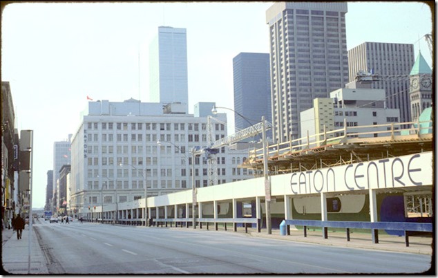
Toronto Eaton Centre (Phase One) in 1977, the year it opened. View gazes north, the fountain in the foreground. Toronto Public Library, tspa 0109978.
I will never forget the opening of the first phase of the Eaton Centre on February 10, 1977, as it was a major event in Toronto’s retail history. On the afternoon of the day it was inaugurated, I travelled on the Yonge subway to the Dundas Street station. The train almost emptied as people excitedly pushed through the turnstiles to reach the underground entrance of the Centre. I was merely sightseeing, but I sensed that most visitors were anxious to take advantage of the opening-day sales.
When Phase One opened in 1977, it only extended from Dundas Street, south to Albert Street. Despite being only half the size of today’s mall, it still appeared massive; it was the largest structure of its type that I had ever experienced. My only basis of comparison was Yorkdale Mall, which had opened it 1964. The Eaton Centre contained five levels, unlike Yorkdale that was mostly on one level, though the Eaton’s and Simpsons department stores contained many storeys.
On my first visit to the Eaton Centre, at the south end where the mall ended, there was a fountain that every five minutes or so sent a stream of water skyward, almost touching the glass roof. It was quite a sight when the fountain suddenly ceased, and the tower of water plunged downward. The fountain still exists today, but I believe that it no longer has the impressive geyser of former years. The mall’s enormous indoor space accommodated many high-end shops that attracted Torontonians and tourists alike.
* * *
History of the Site of the Eaton Centre
Post card depicting the Eaton’s complex at Yonge and Queen in 1920.
Prior to the Second World War, the intersection at Queen and Yonge Streets was the centre of Toronto’s retail trade, the department stores Eaton’s and Simpsons being the major attractions. After the war, many people migrated to the suburbs as they possessed more disposable funds and had purchased automobiles. The intersection of Queen and Yonge was too distant to service the needs of these suburbanites.
The era of the automobile-centred shopping mall commenced. Eaton’s Yorkdale was a response to this need, and was Canada’s first large indoor shopping space. It had huge parking areas to accommodate cars. However, despite Eaton’s expansion into the suburb’s, the company had no intention of neglecting its downtown site.
On March 1, 1966, Cadillac Fairview joined with Eaton’s and announced plans for a new Eaton Centre, an enormous mall that when completed would extend from Queen Street, north to Dundas. However, plans of this scope required several years to coalesce, its design and format changing several times before construction was able to begin. Its architects were the Zeidler Partnership and Bregman and Hamann.
The configuration of the new mall was highly controversial. Many properties, particularly on Yonge Street, needed to be purchased and the buildings on the sites torn down. Initial plans also included the demolition of the Old City Hall and the Church of the Holy Trinity, the latter a heritage building dating back to 1847. However, citizens’ fierce objections put an end to these proposals. A modified plan allowed the City Hall clock tower and the cenotaph to remain, after the Old City Hall was dismantled. This too was refused.
For the next two years, the developers negotiated with the Church of the Holy Trinity. Though plans for the demolition of the church had ended, the congregation still objected to the new proposal as the developers wanted to erect multi-storeyed buildings on the south and west sides of the church. This would entail the loss of sunlight around the church. The Salvation Army Headquarters at Albert and James Streets was another holdout, as the organization did not wish to relinquish its property. The developers finally realized that their original plans were not possible and besides, they were generating too much negative publicity. After more negotiations and compromises, city council finally approved the plans.
When phase one opened in 1977, the new Eaton’s store was at its north end. This facilitated the closing and demolition of the old Eaton’s Queen Street store, so that construction of phase two could begin.
Sources: thecanadianencyclopedia.ca/en/article/eaton-centre and torontoist.com/2017/02/historicist-opening-the-eaton-centre and
blogto.com/city/2010/12/the_origins_of_the_eaton_centre/
The Eaton Centre Site Prior to Construction of the Eaton Centre
Plans submitted in 1967 for the Eaton Centre. The buildings inside the outlined rectangle (bounded by Queen, Dundas, James, and Yonge Streets) were to be demolished. The Old City Hall and Holy Trinity Church were included among the structures to be removed. This plan was soundly rejected. Toronto Public Library, tspa 0108868.
Gazing south on Yonge Street from near Dundas Street in 1972. The buildings on the west side of Yonge (right-hand side) were all demolished to allow construction of the Eaton Centre. In the distance, the tall building near the water tower on a roof, is the old Eaton Store on Queen Street. It was eventually demolished to make way for Phase Two of the Eaton Centre. On the left-hand side of the photo is the marquee of the Downtown Theatre. Today, the site of the theatre is part of Dundas Square. Toronto Public Library, tspa 0110147.
View of Trinity Square and the Church of the Holy Trinity in 1972. The camera is pointed east toward Yonge Street. The marquee of the Imperial Theatre can be seen at the top-left-hand edge of the photo. The four-storey building on the east side of Yonge, with the large window topped by a Roman arch, is 241 Yonge Street, which still exists today. All the buildings on the east side of Yonge Street were demolished. Photo from the Toronto Public Library, tspa 0110944.
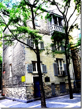
Scadding House in 1973, amid the construction of the Eaton Centre. It was to the east of the Church of The Holy Trinity, the street in front of it extending east to Yonge Street. To build the Eaton Centre, it was necessary to relocated the house 150 feet to the west. In the background of the photo, the “Imperial Six Theatre” on Yonge Street can be seen. It has the large round window. Toronto Public Library, tspa 019995.
(left) Relocating Scadding House in 1974. tspa 019797. (Right) Scadding House in 2015 after it was restored.
Construction of phase one the Eaton Centre (from Dundas to Albert Street)
Artist’s sketch drawn in 1972, gazing south on Yonge from Dundas Street. This was how the artist envisioned the east side of Yonge after the Eaton Centre was completed. Alas, it did not become the animated, people-friendly exterior that the artist depicted. Toronto Public Library, tspa 0110003
Gazing west on Albert Street in 1972. All the buildings on the north (right-hand side) of Albert Street were demolished to erect Phase One of the Eaton Centre. The Eaton’s Queen Street store is on the south side of Albert (left-hand side of photo). It was demolished to build Phase Two. The Canada Life Building on University Avenue can be seen in the distance, at the end of the street. The section of Albert Street between Yonge and James Street is today absorbed into the Eaton Centre. Toronto Public Library, tspa 010996.
View gazes east on Dundas Street in 1973, a short distance west of Yonge Street. Workmen are demolishing the buildings on the southwest corner of Yonge and Dundas. On the northeast corner is the famous Brown Derby Tavern. Toronto Public Library tspa 0109960.
View gazing west at the site of Phase One in 1974, after the buildings had been demolished. The old Eaton Queen Street store is at the south end of the cleared site. It remained open for business until Phase One was completed. The Old and New City Halls are visible. The street that extends the full length of the photo (on the right-hand side) is Dundas Street West. Yonge Street is in the foreground. Toronto Public Library, tspa 0109954.
View looking south on Yonge Street in 1975, the east side of the street cleared of buildings. The Eaton Centre is under construction behind the hoarding. Eaton’s Queen Street store is at the south end of the construction site. Beyond it, a sliver of the Simpsons store can be seen. Toronto Archives, Fonds 1526, File 84, item 60.
View of Phase One as it is nearing completion in 1976. In the photo, at the south end of Phase One is Albert Street. The Church of the Holy Trinity is visible on the west side of Phase One of the Eaton Centre. Toronto Public Library tspa 0109984.
View of the interior in 1976, as construction of Phase One nears completion. The camera is pointed south toward Albert Street, where the mall terminates. Behind the wall at the far end was where Phase Two would eventually appear. Toronto Public Library, tapa 0109988.
Opening day of the Eaton Centre in 1977. View gazes west, Yonge Street in the foreground. The expansive glass-roofed entrance on Dundas Street is visible. Toronto Public Library, taps 010999.
View of the Centre Court of Phase One of the Eaton Centre in 1977. The camera faces east toward Yonge Street. Toronto Public Library, tspa 0109970.
The north end of Phase One of the Eaton Centre in 1977. Toronto Public Library, tspa 0110001.
View of the Eaton Centre in 1978 from the corner of Yonge and Dundas Streets. Photo from the Ontario Archives.
For a link to Phase Two of the Eaton Centre:
https://tayloronhistory.com/2018/01/19/torontos-eaton-centre-phase-two-history/
To view the Home Page for this blog: https://tayloronhistory.com/
For more information about the topics explored on this blog:
https://tayloronhistory.com/2016/03/02/tayloronhistory-comcheck-it-out/
Books by the Blog’s Author
“ Lost Toronto”—employing detailed archival photographs, this recaptures the city’s lost theatres, sporting venues, bars, restaurants and shops. This richly illustrated book brings some of Toronto’s most remarkable buildings and much-loved venues back to life. From the loss of John Strachan’s Bishop’s Palace in 1890 to the scrapping of the S. S. Cayuga in 1960 and the closure of the HMV Superstore in 2017, these pages cover more than 150 years of the city’s built heritage to reveal a Toronto that once was.
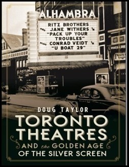
“Toronto’s Theatres and the Golden Age of the Silver Screen,” explores 50 of Toronto’s old theatres and contains over 80 archival photographs of the facades, marquees and interiors of the theatres. It relates anecdotes and stories by the author and others who experienced these grand old movie houses. To place an order for this book, published by History Press:
Book also available in most book stores such as Chapter/Indigo, the Bell Lightbox and AGO Book Shop. It can also be ordered by phoning University of Toronto Press, Distribution: 416-667-7791 (ISBN 978.1.62619.450.2)
“Toronto’s Movie Theatres of Yesteryear—Brought Back to Thrill You Again” explores 81 theatres. It contains over 125 archival photographs, with interesting anecdotes about these grand old theatres and their fascinating histories. Note: an article on this book was published in Toronto Life Magazine, October 2016 issue.
For a link to the article published by |Toronto Life Magazine: torontolife.com/…/photos-old-cinemas-doug–taylor–toronto-local-movie-theatres-of-y…
The book is available at local book stores throughout Toronto or for a link to order this book: https://www.dundurn.com/books/Torontos-Local-Movie-Theatres-Yesteryear
“Toronto Then and Now,” published by Pavilion Press (London, England) explores 75 of the city’s heritage sites. It contains archival and modern photos that allow readers to compare scenes and discover how they have changed over the decades. Note: a review of this book was published in Spacing Magazine, October 2016. For a link to this review:
spacing.ca/toronto/2016/09/02/reading-list-toronto-then-and-now/
For further information on ordering this book, follow the link to Amazon.com here or contact the publisher directly by the link below:
http://www.ipgbook.com/toronto–then-and-now—products-9781910904077.php?page_id=21
![1977 tspa_0109978f[1] 1977 tspa_0109978f[1]](https://tayloronhistory.com/wp-content/uploads/2018/01/1977-tspa_0109978f1_thumb.jpg)
![Wikipedia Eatonstoronto1920MainStore[1] Wikipedia Eatonstoronto1920MainStore[1]](https://tayloronhistory.files.wordpress.com/2015/10/wikipedia-eatonstoronto1920mainstore1_thumb.jpg?w=674&h=458)
![plans, 1967. tspa_0108868f[2] plans, 1967. tspa_0108868f[2]](https://tayloronhistory.com/wp-content/uploads/2018/01/plans-1967-tspa_0108868f2_thumb.jpg)
![east side on Yonge 1972. tspa_0110147f[1] east side on Yonge 1972. tspa_0110147f[1]](https://tayloronhistory.com/wp-content/uploads/2018/01/east-side-on-yonge-1972-tspa_0110147f1_thumb.jpg)
![east to Yonge, 1972 tspa_0110944f[1] east to Yonge, 1972 tspa_0110944f[1]](https://tayloronhistory.com/wp-content/uploads/2018/01/east-to-yonge-1972-tspa_0110944f1_thumb.jpg)
![1973 tspa_0109995f[1] 1973 tspa_0109995f[1]](https://tayloronhistory.com/wp-content/uploads/2018/01/1973-tspa_0109995f1_thumb.jpg)
![tspa_0109997 relocating Scadding House, 1974 [1] tspa_0109997 relocating Scadding House, 1974 [1]](https://tayloronhistory.com/wp-content/uploads/2018/01/tspa_0109997-relocating-scadding-house-1974-1_thumb.jpg)
![east side, Yonge St. sketch done in 1976, of concept when done in 1972. drawing 1972 tspa_0110003f[1] east side, Yonge St. sketch done in 1976, of concept when done in 1972. drawing 1972 tspa_0110003f[1]](https://tayloronhistory.com/wp-content/uploads/2018/01/east-side-yonge-st-sketch-done-in-1976-of-concept-when-done-in-1972-drawing-1972-tspa_0110001.jpg)
![Yonge and Albert 1972 tspa_0109996f[1] Yonge and Albert 1972 tspa_0109996f[1]](https://tayloronhistory.com/wp-content/uploads/2018/01/yonge-and-albert-1972-tspa_0109996f1_thumb.jpg)
![1973 tspa_0109960f[1] 1973 tspa_0109960f[1]](https://tayloronhistory.com/wp-content/uploads/2018/01/1973-tspa_0109960f1_thumb.jpg)
![1974. tspa_0109954f[1] 1974. tspa_0109954f[1]](https://tayloronhistory.com/wp-content/uploads/2018/01/1974-tspa_0109954f1_thumb.jpg)
![1976 tspa_0109984f[1] 1976 tspa_0109984f[1]](https://tayloronhistory.com/wp-content/uploads/2018/01/1976-tspa_0109984f1_thumb.jpg)
![early 1976, construction tspa_0109988f[1] early 1976, construction tspa_0109988f[1]](https://tayloronhistory.com/wp-content/uploads/2018/01/early-1976-construction-tspa_0109988f1_thumb.jpg)
![opening in 1976. tspa_0109999f[1] opening in 1976. tspa_0109999f[1]](https://tayloronhistory.com/wp-content/uploads/2018/01/opening-in-1976-tspa_0109999f1_thumb.jpg)
![1977. tspa_0109970f[1] 1977. tspa_0109970f[1]](https://tayloronhistory.com/wp-content/uploads/2018/01/1977-tspa_0109970f1_thumb.jpg)
![1977 tspa_0110001f[2] 1977 tspa_0110001f[2]](https://tayloronhistory.com/wp-content/uploads/2018/01/1977-tspa_0110001f2_thumb.jpg)
![1978. I0016047[1] 1978. I0016047[1]](https://tayloronhistory.files.wordpress.com/2015/10/1978-i00160471_thumb.jpg?w=699&h=479)
![image_thumb6_thumb_thumb_thumb_thumb[1] image_thumb6_thumb_thumb_thumb_thumb[1]](https://tayloronhistory.com/wp-content/uploads/2018/01/image_thumb6_thumb_thumb_thumb_thumb1_thumb4.png)